Nawada district
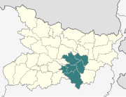
District of Bihar in IndiaNawada district is one of the thirty-eight districts of the Indian state of Bihar. Nawada is its administrative headquarters. The district is the easternmost district of the Magadh division, one of the nine administrative divisions of Bihar. The area of the modern district was historically part of the Magadha, Shunga and Gupta empires. Koderma and Giridih districts of the state of Jharkhand lie on the southern border of the district; it also shares borders with the Gaya, Nalanda, Sheikhpura, and Jamui districts of Bihar.
Read article


Top Questions
AI generatedMore questions
Nearby Places

Gaya (India)
City in Bihar, India

Jehanabad district
District of Bihar in India
Munger division
Division of Bihar in India

Magadh division
Division of Bihar in India

Gaya district
District in Bihar, India
Mohana River
River in Bihar, India
Khiriyawan
Government Polytechnic, Gaya
Public technical institute in Bihar, India